We have investigated some short walks and
provide some simple maps to suggest the paths. These should only be
taken as a guide as each individual's fitness and strength must be
considered when deciding if these walks are appropriate. If the
stairs are a problem just turn around and return the way you got to
them. Many provide excellent cliff top vantage points for whale or
seal watching if you are lucky enough to be in the right season (eg
May/October). If you are looking for a longer and slightly more
demanding walk, why not do the Petmans
Beach Walk?
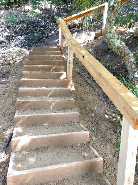
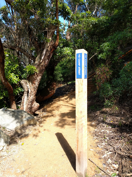
I was pleasing the other day (October 2016) to go for a walk and find the Shire has been active and replaced the old steps around out walking trails with brand new constructions complete with very solid infill. They have also placed new signs as well in very solid posts to give walkers guidance as to where they might be. Here are some sample's on the way from the Tavern to the foreshore car park and up the stairs to Camp Street and back down Lake Tyers Beach Road to the Tavern.
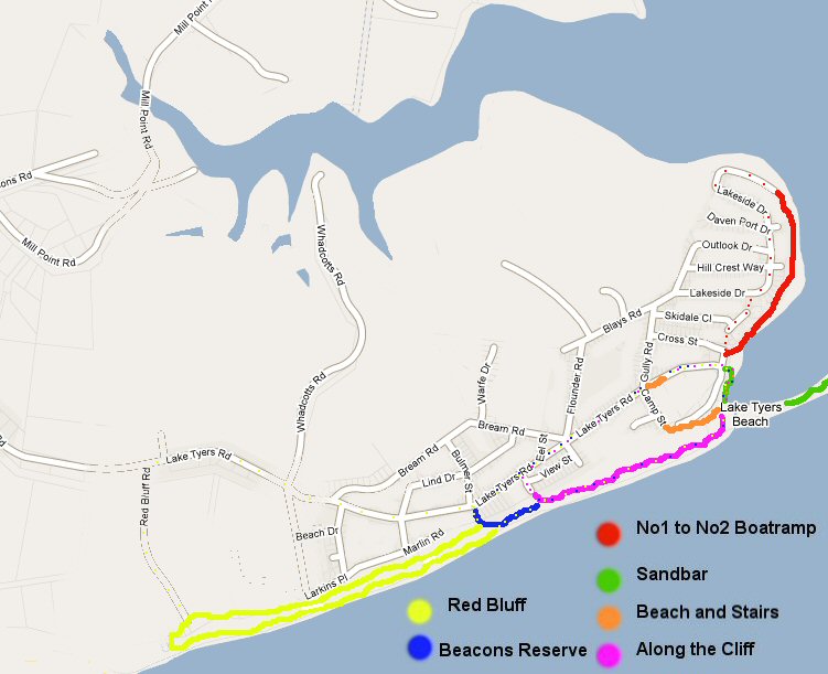
Here is a small map to help you find your way around the town and surrounding areas. Most are not too strenuous, but need to be checked out if you are unsure. Generally the tracks are well marked but occasionally go across places where people have (illegally) taken over and created mowed front lawns. Then the track is not obvious but just look over the other side and you see where the exit back in tot he natural bush is.
All these descriptions assume you will be beginning and ending at the
car park at the front of the Tavern. If not, adapt the walks
accordingly.I was pleasing the other day (October 2016) to go for a walk and find the Shire has been active and replaced the old steps around out walking trails with brand new constructions complete with very solid infill. They have also placed new signs as well in very solid posts to give walkers guidance as to where they might be. Here are some sample's on the way from the Tavern to the foreshore car park and up the stairs to Camp Street and back down Lake Tyers Beach Road to the Tavern.
 |
 |
Here is a small map to help you find your way around the town and surrounding areas. Most are not too strenuous, but need to be checked out if you are unsure. Generally the tracks are well marked but occasionally go across places where people have (illegally) taken over and created mowed front lawns. Then the track is not obvious but just look over the other side and you see where the exit back in tot he natural bush is.
 Hotel
Car Park to Beacon
Reserve and return: Total 2.6km and about 50mins moderate
speed walking. Hotel
Car Park to Beacon
Reserve and return: Total 2.6km and about 50mins moderate
speed walking. |
Directions: Walk to the beach (about0.3km) and turn west along the beach, sandy walk for 1.0 km to a white pole at back of the beach marked Beacon Reserve. Head inland to a set of steps that rise about 30m, turn left at the top and follow the track out to Lake Tyers Beach Road, turn left and take an easy walk down hill along the nature strips back to the hotel car park. |
 Number1
Boat Ramp to Number 2 Boat Ramp and return: Total 1.1km about 20
minutes moderate speed walking. Number1
Boat Ramp to Number 2 Boat Ramp and return: Total 1.1km about 20
minutes moderate speed walking. |
Directions: Walk to north end of hotel car park and head up the path behind the railing. The gravel track is an easy stroll and is about 0.5km and can be returned via the side of the Lake if it is low, or back up along Lakeside Drive to the gap at the top of the hill, and then cut through to Skidale Court and back to the Hotel Car Park (longer than returning on the path). |
| Hotel
Carpark to Beach and Stairs and return: Total 0.92km, about
20mins moderate speed walking |
Directions: Begin at the Hotel Car Park and head out to the beach, at the end of the path look ot the right for the foreshore Car Park and then walk through the car park to the end and find the pole with Camp St on it, behind that there are stairs up to Camp St. The stairs climb about 20m and land you on Camp St. Wander out to Lake Tyers Beach Road and down to the car park. |
 Hotel
Car Park to Sandbar and return: Total 1.5km and about 40mins
stroll on the sand. Hotel
Car Park to Sandbar and return: Total 1.5km and about 40mins
stroll on the sand. |
Head out along the lakes edge to the beach and feel the freshness of the 90 Mile Beach experience. Walking across the sandbar you will be crossing points where the bar has opened numerous times over the years. To the left the serenity of the lake, to right thpower of the surf. |
 Along
the Cliff Along
the CliffHotel Car Park to View Street and return along beach, 2.1km about |
Probably best to begin this one by walking back up Lake Tyers Beach road first, until you get to View Street, and then turn left along the made road (for 20-30m) until a small gap int he bush at the corner will indicate the path down to the beach. The steps are fair, but not all even in the drop for each step. The entry onto the beach is hard to pick and easily missed traveling along the beach first. |
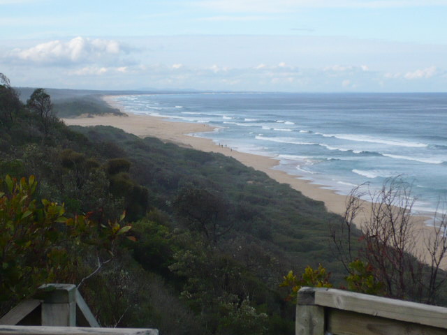
 All
the way to Red Bluff All
the way to Red BluffWalking along the beach first, one can return via the bush tracks or the made road back along Lake Tyers Beach Road. |
Beginning at the hotel car park, go the 340 meters out to the beach and turn right. By the time you have walked west for about 45 minutes you will be near the stairs (that begin close to the back of the beach) up to the lookout. This is 2.6km from the hotel car park, and depending on how you return it is another 2.4km to the hotel car park threading back along the Cliff Top Walk (see east end of car park) which has excellent information boards on geology, flora and fauna, plus seats every now and then to sit and soak up the atmosphere. The simpler way but not half so exciting is to walk out to Lake Tyers Beach Road and along the road on the walking footpath. This distance is about 2.6km easy walking. |
For a quick review to whet your appetite click here.
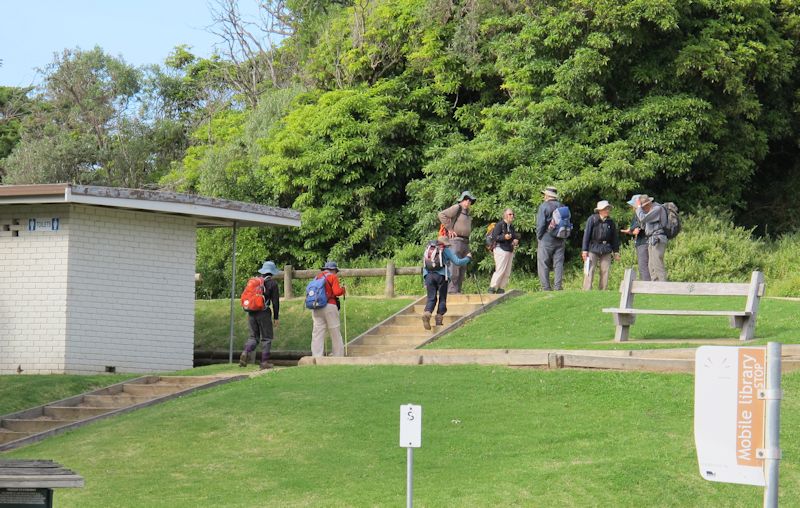
Now these folks are taking the whole thing very seriously, very well kitted out, but usually water bottle, runners, shorts and T-shirt are sufficient.
If you are really
serious about your bush walking and looking for some real inspiration
with a wholesome dob of nostalgia then I can highly recommend this site
by the Melbourne Walking Club. They have scanned their
newsletters
from 1929 to 1969 and published them. They have a long history of
visiting and highlighting East Gippsland as a great destination. For
many of us it will take us back to the dreamy days of the 50s and 60's
when Paddy Pallin, the Silva Compass and Flinders Ranges gear was de
rigeur!
I