


Bike Trail Joining
Nowa Nowa to Lake Tyers beach
and Lakes Entrance
via Burnt Bridge
There is a proposal to construct a bike trail from Nowa Nowa down to where Burnt Bridge is, through to Lake Tyers Beach and onto Lakes Entrance.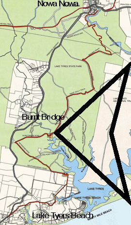 |
The trail can be seen in red coming from Nowa Nowa and
mainly using
existing roads to head down to where Burnt Bridge was. From
there it
continues along made roads (but not on the highway) to the BungYarnda
information site, then through to Mill Point and Lake Tyers Beach.
Keen riders can then continue onto to Lakes Entrance.
Obviously the
return trip will be preferable for people staying near the coast.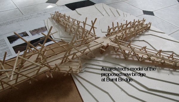 To keep riders off the highway the rebuilding of Burnt Bridge is essential? |
In early 2010, Michael Ryan
along with
SLAP Architects began to develop the idea of a bicycle/pedestrian
route, which linked Lakes Entrance and Nowa Nowa. This came about, as
cycling along the Princes Highway is considered too dangerous due to
the high volume of traffic. Furthermore the existing Rail Trail which
runs from Bairnsdale, passing through Nicholson and Nowa Nowa then
terminating in Orbost does not provide a link between Lakes Entrance
and Nowa Nowa. Additionally the section of Rail Trail which runs
between Nicholson and Nowa Nowa can be too challenging for most
cyclists, due to the steep inclines throughout the section.
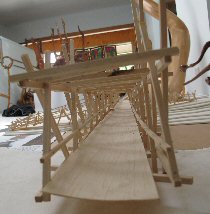 The proposed
bicycle/pedestrian route linking Lakes Entrance and Nowa Nowa can be
achieved through utilizing minor existing public roads and tracks which
run throughout Lake Tyers
State Park. With the addition of several small sections of track along
with a two bridges one over the Toorloo Arm waterway and a much smaller
bridge to transverse a small lake arm between Mill Point Road and South
Boundary
Road. The distance of the Proposed Bicycle/Pedestrian route is
approximately 31km from Lakes Entrance to Nowa Nowa and can be ridden
in 2-3 hours and walked in 5-6 hours depending on physical fitness.
This track will also show case the natural beauty and history of the
Lake Tyers State Park.
The proposed
bicycle/pedestrian route linking Lakes Entrance and Nowa Nowa can be
achieved through utilizing minor existing public roads and tracks which
run throughout Lake Tyers
State Park. With the addition of several small sections of track along
with a two bridges one over the Toorloo Arm waterway and a much smaller
bridge to transverse a small lake arm between Mill Point Road and South
Boundary
Road. The distance of the Proposed Bicycle/Pedestrian route is
approximately 31km from Lakes Entrance to Nowa Nowa and can be ridden
in 2-3 hours and walked in 5-6 hours depending on physical fitness.
This track will also show case the natural beauty and history of the
Lake Tyers State Park.
It has been envisioned that the proposed route will attract people to the East Gippsland region and provided extensive access to the Lake Tyers State Park and associated waterways. Additionally it has been recognised by the Healthy Parks, Healthy People campaign run by Parks Victoria that the development of infrastructure throughout existing state parks brings environmental, economical and social benefits to the local, regional, state and national communities. It has also been established that accessible parks lead to social cohesion, social capital and healthy communities.
The development of the proposed bicycle/pedestrian route linking Lakes Entrance and Nowa Nowa will benefit not only the local communities surrounding the Lake Tyers State Park and waterways, but will provide an accessible resource to be utilized by all members of the public.
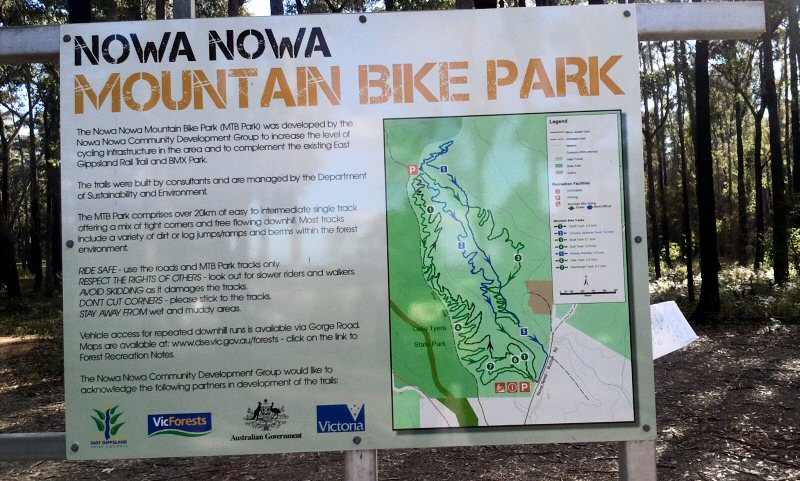
Nowa Nowa Mountain Bike Park
There is also another great cycling attraction for the more energetic and adventurous 1 km from Nowa Nowa.
The proposed
bicycle/pedestrian route linking Lakes Entrance and Nowa Nowa can be
achieved through utilizing minor existing public roads and tracks which
run throughout Lake Tyers
State Park. With the addition of several small sections of track along
with a two bridges one over the Toorloo Arm waterway and a much smaller
bridge to transverse a small lake arm between Mill Point Road and South
Boundary
Road. The distance of the Proposed Bicycle/Pedestrian route is
approximately 31km from Lakes Entrance to Nowa Nowa and can be ridden
in 2-3 hours and walked in 5-6 hours depending on physical fitness.
This track will also show case the natural beauty and history of the
Lake Tyers State Park.It has been envisioned that the proposed route will attract people to the East Gippsland region and provided extensive access to the Lake Tyers State Park and associated waterways. Additionally it has been recognised by the Healthy Parks, Healthy People campaign run by Parks Victoria that the development of infrastructure throughout existing state parks brings environmental, economical and social benefits to the local, regional, state and national communities. It has also been established that accessible parks lead to social cohesion, social capital and healthy communities.
The development of the proposed bicycle/pedestrian route linking Lakes Entrance and Nowa Nowa will benefit not only the local communities surrounding the Lake Tyers State Park and waterways, but will provide an accessible resource to be utilized by all members of the public.
Nowa Nowa Mountain Bike Park
There is also another great cycling attraction for the more energetic and adventurous 1 km from Nowa Nowa.
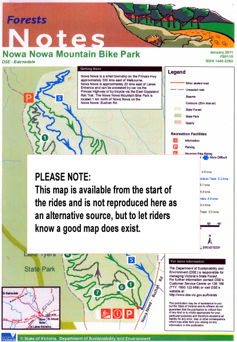 |
This document has been prepared by the DSE - Bairnsdale and possibly be picked up in Nowa Nowa before starting on the Mountain Bike Park rides. Its availibilty is not guaranteed. However the map is replicated at the start of rides and on the DSE site as a PDF Document. It will make it easy for planning of appropriate rides. These are some of the track names and distances: Skull Track (5.7 km) Scat Track (5.9 km) Jumping Jackeroo Track (5.2 km) Heartbreak Track (0.5 km) Little Track (0.3km) Wallaby Ramble (4.8 km) Uphill Track (4.9 km) Sounds like some interesting challenges thrown out there folks.... Telephone Numbers DSE Customer Service : 136 186 Freecall: 1800 122 969 (not free on mobiles) Website: www.dse.vic.gov.au/forests |